 English
 Italian
Please use this identifier to cite or link to this item:
http://hdl.handle.net/20.500.12835/66718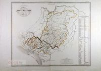
| Title: | CARTA DEGLI STATI ESTENSI AVANTI IL DOMINIO DEI ROMANI SOTTO IL GOVERNO DEI MEDESIMI E NEL MEDIO EVO | Main Authors(Role): | Maina, Giacinto <Lubiana?, 1775 ca. - 1850 ca.> (Incisore) Stanghi, V. <Firenze?, op. dal 1840 al 1860 ca.> (Incisore) |
Secondary Authors(Role): | Manzoni, Pietro <Firenze?, op. dal 1840 al 1845 ca.> (Incisore) Zuccagni Orlandini, Attilio (Editore) |
Fond: | Raccolta Stampe sciolte Biblioteca Panizzi (Raccolta) | Is Engraving of: | Corografia fisica, storica e statistica dell'Italia e delle sue isole corredata di un atlante di mappe geografiche e topografiche e di altre tavole illustrative di Attilio Zuccagni Orlandini eseguita a cura e spese della Società editrice e proprietaria de|ll'opera... | Subject: | Italia settentrionale - Carte geografiche antiche | Extrinsic Description: | CARTA DEGLI STATI ESTENSI AVANTI IL DOMINIO DEI ROMANI SOTTO IL GOVERNO DEI MEDESIMI E NEL MEDIO EVO / G. Maina, e Stanghi inc. ; P. Manzoni scrisse. - 1 carta geografica : acquaforte e bulino ; 535 x 660, 600 x 740 mm. | Signature: | RSBP.7608.Raccolta Iacinto | URI: | http://hdl.handle.net/20.500.12835/66718 |
| Appears in Collections: | 1.Stampe e disegni |
Show full item record
Items in DSpace are protected by copyright, with all rights reserved, unless otherwise indicated.